Amid the regular and dangerous GPS jamming in the Baltic and Black Seas, which European governments directly link to the Russia’s hybrid actions, our expert Eduard Pleshko talks about the Crimean trail of radio interference bursts that disabled satellite navigation over vast areas, creating direct threats to aviation and maritime transport.
Between January 2019 and April 2026, most often on Tuesdays, Wednesdays and Thursdays during business hours European time, 75 days were recorded when powerful signal jamming events occurred in the “GPS L1” frequency range, centered on 1575.42 megahertz.
The detected powerful radio signal was transmitted in a narrow 5 megahertz band centered at 1577.5 megahertz, which is close to the civilian GPS L1 band, and similar bursts were also recorded on the frequency of the Chinese navigation system “BeiDou”, which has its signal centered at 1558.5 megahertz. The detected interference signals were hundreds of times stronger than the original navigation signals.
A research team led by Professor Todd Humphreys from the University of Texas, together with specialists from Stanford University, conducted a large-scale analysis of data from ground stations receiving signals from global navigation satellite systems (GNSS). Scientists have discovered a clear pattern of high-power interference that lasts less than 10 seconds, but simultaneously covers the territory from Norway to Spain and Poland, and sometimes reaches Greenland and Canada.
The results of the study completely refuted the version of random technical malfunctions or the influence of solar activity and pointed to systematic human activity. Previously, given the geographical area of frequent detection of interference, one of the working versions that got into the media was an attempt to identify the source of interference in the territory of the Kaliningrad enclave of Russia.
However, the truth turned out to be somewhat different, although directly related to Russia. The decisive factor was the raw radio signal data recorded by stations in Amsterdam and Trondheim during the event on February 11, 2026. The researchers managed to build a mathematical model of space and, having calculated the difference in the time of arrival of the signal, establish with an accuracy of up to 200 meters the location of the radiation source.
Since the anomaly simultaneously affected receivers at a distance of thousands of kilometers, Todd Humphreys and his colleagues found that the radiation source must be at an altitude of at least 1,200 kilometers above the Earth. The results obtained perfectly coincided with the highly elliptical orbit of the Russian satellite “Kosmos-2546”, which was detected among more than 15,000 satellites according to the criterion of “direct visibility” during the failures.
Since “Kosmos-2546” could not perform jamming in 2019, the researchers concluded that the interference was generated by the entire group of six similar satellites of the Russian “Kupol” system.
The single “Kupol” space system is the key space echelon of the Russian Missile Warning System, which consists of six “Tundra” (14F142) satellites, bearing the numbers “Kosmos-2510” launched in November 2015, “Kosmos-2518” launched in May 2017, “Kosmos-2541” launched in August 2019, “Kosmos-2546” launched in May 2020, “Kosmos-2552” launched in November 2021, and “Kosmos-2563” launched in November 2022.
All six vehicles were launched using “Soyuz-2.1b” launch vehicles with “Fregat” boosters from the Russian Plesetsk Cosmodrome and operate in high elliptical orbits, recording the thermal radiation of the flares of the ballistic missile engines at the moment of launch.
For a satellite that is designed to detect heat signatures and supposedly has a defensive purpose – to provide early warning of a missile attack, such dual use is not just strange, but becomes a de facto confirmed means of attack in the electromagnetic spectrum domain.
The shift of the actual interference frequency by several megahertz relative to the civilian “GPS” frequency gives reason to believe that the Russia is deliberately “not revealing the map” completely so as not to provoke a global scandal, but regularly tests the operability of the transmitters. In the event of a real conflict, the frequency will easily be shifted directly to the center of the “GPS” range, which will lead to the “blinding” of navigation, financial systems and communications at the level of an entire continent.
But an extremely interesting question is the implementation of control over this Russian satellite group.
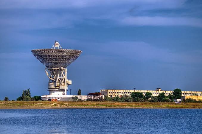
It is worth noting that in addition to the main data processing and control centers of the “Kupol” system, which are concentrated at facilities in the Moscow region and the Far East, as western and eastern command posts, respectively, the system includes the “40th separate command and measurement complex” or military unit 81415, located in Vityno near occupied Yevpatoria, which performs the role of the “southwestern communications hub of the Titov Main Test and Space Systems Control Centre”.
The technical base of the complex was the “RT-70” (“P-2500”) radio telescope with a mirror diameter of 70 meters, as well as the remains of the “Pluton” complexes (“ADU-1000” antennas) and quantum-optical systems of the “Sazhen” family.
Previously, our Association has repeatedly investigated the activities of the “40th complex”, with the involvement of which the occupiers deployed a jamming-resistant information and computing system. It is directly involved in adjusting the time and program tasks for the “GLONASS” navigation system, collecting and verifying data from Russian orbital groups, which directly affects the accuracy of targeting Russian high-precision weapons and the navigation of the aggressor’s combat aircraft.
It should be noted that the antennas of the complex were able to carry out communication sessions, take telemetry and issue control commands to the on-board computers of the “Tundra” spacecraft when they are in the direct radio visibility zone of the southwestern sector. New data from the above-described independent non-governmental study force us to pay more attention to the problem of detected system interference.
Despite the fact that the official Kremlin does not comment on the situation, and the European Union has classified the results of its own investigations, experts see this as signs of preparation for a large-scale electronic warfare.
In particular, Todd Humphreys suggests that now the Russians are only testing equipment on neighboring frequencies, but in the event of a heated conflict they will be able to instantly retune the transmitters directly to the GPS band, which will lead to catastrophic consequences for civilian and military infrastructure. Such actions fit into the general strategy of Russia to neutralize the space assets of the West.
In 2026, representatives of the US Space Command already warned about the deployment of anti-satellite weapons by the Russians. The current proven manipulation of the navigation signal, Professor Humphreys calls a large-scale escalation of the background conflict in electronic space, which is currently underway above the heads of millions of people.
If we assume that the interference is caused by the satellites of the Russian Missile Warning System, a complex international legal precedent arises that must be assessed in two key aspects.
Firstly, this is the destruction of global strategic stability by Russia, when this System is transformed from a fundamental element of nuclear deterrence, which is intended to guarantee the absence of a “sudden” disarming strike and prevent the erroneous start of a nuclear war, into a tool for attack in the electromagnetic spectrum.
The use of strategic defense sensors as offensive weapons or even attempts to use them in electronic warfare against the civilian infrastructure of third countries is a gross violation of the spirit of international agreements on reducing strategic risks. This undermines confidence in the functioning of the warning system itself.
Secondly, such actions of Russia pose a threat to nuclear safety. Although direct jamming of GPS signals by the System’s satellites does not formally fall under the direct violation of the Convention on Nuclear Safety, the deployment of such a radio-electronic capability with a complete blocking of GNSS navigation creates critical threats to logistics, monitoring and power lines that power civilian nuclear facilities in Europe.
For early warning systems for radiation accidents and coordination of actions in emergency situations, which are often tied to precise GPS time.
An important aspect is also Russia’s violation of the Statute of the International Telecommunication Union (ITU) by proven intentional creation of harmful interference in protected international frequency bands, which are frequencies of satellite navigation and safety of life. This can already be assessed as a direct violation of the ITU Radio Regulations. Since Russia is a signatory to these documents, its actions are knowingly unlawful in terms of international law.
Given the above, it becomes clear why Ukraine considers the “40th separate command and measurement complex” a legitimate target under international law and carried out its destruction. Among other things, in early March 2026, the General Staff of the Armed Forces of Ukraine officially confirmed another successful destruction of this center.
We must also respond even to short-term tests or irresponsible technological features of telemetry transmission by Russian nuclear deterrence satellites for manipulation in civilian radio frequency space over Europe.
It is in light of Russia’s demonstration of readiness to use outer space as a springboard for future escalation and the creation of a dangerous precedent of a “gray zone” of hybrid warfare that our Association is determining further response measures.